When your cursor is positioned over any one of the function menus they become visible, however after a period of inactivity the function menus will again become transparent. If you move your cursor off of the function menu it will become transparent more quickly.
|
|
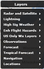
This top level menu contains a number of logical layer groupings that make it easy for you to find the weather information you are looking for more quickly and intuitively. There are multiple sub-menu items that contain logical groupings of weather layers. We will look at the contents of each of the sub-menus below.

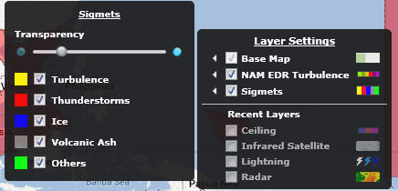
To view a layer select a sub-menu and then click the check box in front of the layer name you want. The layer data will be visible in the content display and the layer will be listed in the Layer Settings menu. Click the check box in the Layer Settings to remove the layer from the content display. The layer will be available under the recently viewed section. Not all map layers are able to be displayed at the same time, this is by design.
You can choose to turn layers off and on in order to view only the data of interest. Some layers are not available at every zoom level, this is by design. Some users may have Custom Layers available in addition to those listed.
|
Radar and Satellite Layers |
This sub-menu contains all relevant layers allowing users to quickly identify storms or approaching storms. It contains Radar, Future Radar, US Only Echo Tops and Storm Corridors, Infrared and Visible Satellite |
|
Radar |
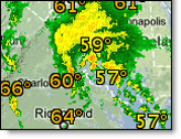
Current composite radar. Includes colors indicating precipitation type and intensity. The transparency is adjustable from the map legend |
|
Future Radar |
Forecast of radar trends for next 90 minutes |
|
Echo Tops (US |
Height of the top of radar reflectivity. Indicated as FL216 where FL is flight level and 216 is 21,600 feet |
|
Storm Corridors (US) |
Forecast path of strong to severe storms along with color indicating type of storm activity. Storm corridors which contain a tornadic vortex signature (TVS) will flash. |
|
Infrared Satellite |
Infrared satellite images are available globally. Transparency of the data can be manipulated from the map legend. |
|
Visible Satellite |
Current visible satellite data available over U.S. and Europe. Transparency of the data can be manipulated from the map legend.
|
|
Lightning |
This sub-menu contains lightning layers both real time and delayed lightning layers. Please note that the Lightning (Real time) is only available to users that have subscribed to the optional service or are AviationSentry Professional or Platinum edition users |
|
Lightning |
Cloud-to-ground and cloud-to-cloud lightning data for a purchased region is depicted by a yellow dotted box. Lightning is color-coded to show age and is updated each minute. To view lightning display options hover over the small arrow in the Map Legend. Set the Total Minutes (5 - 60) of data to display. Select ground, cloud or both types of data to view. Age is shown by color. You may also enable the sliding color scale and/or range rings. Please note that the coverage area varies with your service level. We offer 30 mile up to global coverage. Please contact your sales professional for more information about changing your service level |
|
US Lightning - Delayed |
Same as lightning layer but on covers US and is delayed by 15 minutes. It is not possible to enable alerting based on this level of service. Please contact your sales professional for more information about changing your service level |
|
High Sig Weather (only available for non-helicopter editions) |
This sub-menu contains all of the High Sig Weather layers to allow users to quickly create dynamic map displays containing all required significant weather information to help determine impacts on upcoming flights. Please note that we will be adding very shortly Pressure Centers and Fronts to this menu once available |
|
Tropopause Heights |
Forecast Tropopause Heights on a global scale for 4 forecast periods (6H, 12H, 18H and 24h) |
|
Tropopause Lows |
Forecast Tropopause Lows on a global scale for 4 forecast periods (6H, 12H, 18H and 24h) |
|
Jet Streams |
Forecast jetstreams on a global scale for 4 forecast periods (6H, 12H, 18H and 24h) |
|
Turbulence |
Contoured polygon depicting forecast turbulence from light to severe. |
|
Icing |
Contoured polygons depicting forecast of slight, moderate and heavy icing |
|
Thunderstorms |
Contoured polygons depicting forecast of isolated, occasional and frequent thunderstorm activity. |
|
Volcano Advisory |
Active Volcanos |
|
Volcanic Ash |
Polygons indicating ash activity |
|
Fronts and Pressure Centers (coming Sep 2013) |
Forecast Fronts and High/Low pressure centers on a global scale for 4 forecast periods (6H, 12H, 18H and 24h) |
|
Sig Weather (only available for Helicopter editions) |
This sub-menu contains all of the Significant Weather layers relevant to helicopter operators to allow users to quickly create dynamic map displays containing all required significant weather information to help determine impacts on upcoming flights. Please note that we will be adding very shortly Pressure Centers and Fronts to this menu once available |
|
Turbulence |
Contoured polygon depicting forecast turbulence from light to severe. |
|
Icing |
Contoured polygons depicting forecast of slight, moderate and heavy icing |
|
Thunderstorms |
Contoured polygons depicting forecast of isolated, occasional and frequent thunderstorm activity. |
|
Volcano Advisory |
Active Volcanos |
|
Volcanic Ash |
Polygons indicating ash activity |
|
US Only Wx Layers |
This sub-menu contains the weather layers that are only available for the United States and are not offered for other regions of the globe at the present time |
|
Icing Airmets |
Polygons indicating areas with observed icing conditions that could be a hazard to pilots. |
|
Turbulence Airmets |
Polygons depicting areas with observed weather conditions that could be a hazard to pilots such as moderate turbulence. |
|
IFR/Mtn Obsc Airmets |
Polygons indicating areas covered by Instrument Flight Rule (IFR) conditions/Mountain Obscuration. |
|
Pireps |
Pilot report of actual weather conditions encountered in flight. |
|
TFRs |
Temporary Flight Restrictions (TFR) marked with a flag. The four lowest levels will also include a dashed polygon of the TFR area. Updates once every five minutes |
|
Convective SIgmets |
Polygons indicating areas covered by a Convective SIGMET. Observed thunderstorm activity affecting an area of 3,000 square miles (7,800 km2) or greater, a line of thunderstorms at least 60 nm long, and/or severe or embedded thunderstorms affecting any area that are expected to last 30 minutes or longe |
|
NWS Bulletins |
While hovering, a summary of all alerts in effect for the county will be listed. Click the county to view the full text of each alert currently in effect. The most severe alert will be listed first (warnings first, then watches, then advisories). |
|
Observations |
This sub-menu contains current weather observation layers only with the exception of the TAF layer. The TAF layer has been grouped in this category to be with the METAR layer to allow users to find these layers together. We have also added the Density Altitude layer to all non-helicopter editions. |
|
METARs |
Observation sites reporting Visual and/or Instrument Flight Rules. The layer also includes both ceiling and visibility. This layer, when selected, will always appear on top of all weather layers. |
|
TAFs |
Graphical color-coded Terminal Area Forecast indicating the flight category of the first TAF forecast period |
|
METARs & TAFs |
Point locations of surface observation and aviation forecasts. The Wx symbol indicates that a METAR is available at this location. Underlined symbols indicate both a METAR and a TAF are available. Color-coded based on expected flying conditions |
|
Sigmets |
Polygons indicating areas covered by a SIGMET. Observed severe weather conditions that could be a hazard to pilots. Criteria include severe or greater turbulence, icing or Instrument Meteorological Conditions (IMC) due to dust, sand, or volcanic ash over a 3,000-square-mile (7,800 km2) area. |
|
Temperatures |
Observed temperature data. Color scale indicates temperature value |
|
Dew Point |
Dew Point for each observation site. The values are color-coded |
|
Visibility |
Observed visibility at ground level measured in miles or meters. |
|
Wind Speed/Dir |
Observed wind speed and wind direction. Color scale indicates knots |
|
Density Altitude |
Contoured layer of density altitude displayed in iso-lines of 1000 foot increments |
|
Unofficial Obs |
Point locations of unofficial surface weather observations from other sources. The capabilities of unofficial observation stations vary and not all stations report all conditions. Not available at the Global zoom level |
|
Forecasts |
This sub-menu contains the industry most accurate Ceiling, Visibility and Flight Category forecasts that cover North America as well as Europe |
|
Ceiling |
Contoured polygon indicating forecast Low Instrument Flight Rules (LIFR), Instrument Flight Rules (IFR) and Marginal Visual Flight Rules (MVFR). |
|
Visibility |
Contoured polygon indicating forecast LIFR, IFR and MVFR |
|
Flight Category |
Contoured polygon combines forecast ceiling and visibility data. |
|
Tropical Forecast |
This sub-menu contains all layers related to our Global tropical forecasts for Hurricanes, Cyclones and tropical storms |
|
Official Track |
Displays all past and forecast positions of one or all active storms. The data is updated every six hours or more frequently as needed. |
|
Track Probability |
A corridor over both land and water of the probable track of the storm is displayed. |
|
Wind |
A color-coded contoured forecast of wind data values over both land and water areas is displayed. |
|
Rainfall |
A color-coded contoured forecast of rain data values over both land and water areas is displayed |
|
Wave Height |
Displays color-coded contoured data values over water areas. |
|
Storm Surge |
Displays color-coded contoured data values over water areas. |
|
All Model Tracks |
This layer displays all of the model tracks available for a given storm |
|
Navigation |
This sub-menu contains the layers that are related to navigation flight data only available for the United States and Europe at this time. A global set will be available before the end of this year. |
|
Airports |
Airports with runways of greater than 8000 feet. |
|
Other Airports |
Smaller airports, usually having runways less than 5000 feet. Labels are available at closer zoom levels. |
|
Heliports |
Non-medical heliports. Labels are available at closer zoom levels. |
|
Medical Heliports |
Hospitals and medical facilities with heliports. Labels are available at closer zoom levels. |
|
High Airways |
High-level air routes. |
|
NAT Tracks |
North Atlantic Tracks |
|
Special Use Airspace |
Special Use Airspace (SUA) boundaries. |
|
ARTCC |
Air Route Traffic Control Center (ARTCC) boundaries |
|
Low Airways |
Low-level air routes. |
|
Fixes |
Navigational fixes. |
|
Navaids |
Navigational aids |
|
My Routes |
Plot your route. Hover over endpoints to view additional information. |
|
Locations |
This sub-menu contains the weather layers that are related to user locations, forecast stations and US counties. There is also a layer only available in all Helicopter editions that is Gulf Lease Lines |
|
User Locations |
Custom locations that you or your Account Administrator have created. |
|
Forecast Station |
Official forecast stations. |
|
Counties |
US County lines |
|
Gulf Lease Lines |
Gulf of Mexico lease line segments |
For all layers that have a small left pointing arrow in front of the layer name, there are options that you can select or adjust for that layer. By simply hovering the mouse pointer above the arrow, the layer options will appear to the left of the menu. You can then select or adjust what is needed.

Hover over data from one of your selected layers to view additional details observed at the official reporting site. A single mouse click will load the forecast from the nearest reporting site, while a double click will zoom the map in one level.