Storm Corridors
The storm corridors can be viewed by clicking the Storm Corridors layer
within the Weather Layers. Storm corridors depict the area which the storm
cell is expected to impact over the next half hour. The corridors are
color-coded based on the type of activity detected in the storm cell by
NEXRAD.
|

Heavy
Rain |
Intense precipitation, strong wind and/or small hail has
been detected. |
|

Severe
Hail |
An event having at least a 25% probability of severe hail
(with a diameter of 3/4" or greater) has been detected. |
|

Dangerous
T-Storm |
A strong thunderstorm with a mesocyclone (rotation aloft)
having an index of 1 or greater has been detected. |
|

Possible
Tornado |
A thunderstorm with a tornadic vortex signature (TVS) has
been detected. Corridors depicting a TVS will flash. |
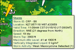
Corridors are not available at the two
widest zoom levels. Additional information is available by clicking the
Get Details icon and hovering over the displayed corridor.
|
Detected Activity |
Definition |
|
Hail |
The probability of hail and/or severe hail (diameter of
3/4" or greater) and the maximum size expected. |
|
Mesocyclone |
Rotation detected at multiple levels in a storm and the
stringent wind and wind shear criteria are met. Strength is categorized
using an index of 1 - 6+. |
|
Tornadic Vortex Signature (TVS) |
Indication of a possible tornado. Strong wind shear has
been detected in a very small area and is usually associated with a potential
tornadic circulation within a thunderstorm. |
The following radar reported index value representing the strength of
a mesocyclone signature is used within storm corridors.
|
Value |
Descriptor |
Definition |
|
0 |
None |
No mesocyclone detected |
|
1 - 2 |
Weak |
Weak mesocyclone detected |
|
3 - 5 |
MDT |
Moderate mesocyclone detected |
|
6+ |
Strong |
Strong mesocyclone detected |
|
255 |
Error |
Error condition |
|
Length |
30 minutes |
|
Width |
One mile |
|
Deviation Angle |
Five degrees |
