Remote Alerting (optional purchase)
Remote Alerting is an optional purchase.
If purchased, you can set alerts for your desktop and remote alerts for your mobile device or email to let you know when certain weather events are approaching or affecting your locations. For the remote alerting, each of your locations can be set to alert separate email or text message addresses. Email addresses may be group addresses to reach more employees.
|
|
Remote Alerting (optional purchase) |
Alerts for your locations will continue to be generated even if you are not signed in to MxVision AviationSentry Online®, however you will not receive notification via the flashing View Alert button or audible alarm.
Select the criteria which when exceeded, will generate an alert in MxVision AviationSentry Online® and cause the View Alerts button to flash red. If selected, an audible alarm will also be sounded on your desktop. All locations created will automatically use the alert criteria setting of your default location, therefore you may wish to set your default alert criteria prior to creating additional locations. Alert criteria and recipient assignments for individual locations can be edited at any time.
If you are under administrator control your Account Administrator will determine your alerting preferences.
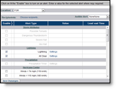
Within the Settings Menu, click the Alerts Menu option and the Alert Criteria submenu option.
Choose a Location and select
an Audible Alert. You may wish to set up your default location alerts
first. All locations created after your default location alerts have been
set will conveniently and automatically use the same alert criteria.
Note: You must have sound capability on your PC to play alarm
sounds. If you have selected an audible alarm and the test sound is not
heard, you may need to install Active X. Typically a banner appears across
the top of your screen with instructions.
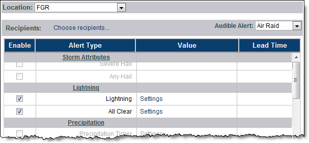
Enable the alert types that you wish to receive. For some alert types you will need to enter one or more values. Each location may have its own criteria with the exception of Lightning settings. Some alert types are only available in specified regions of the globe. A complete listing is located in Alert Descriptions.
Select a lead time between one and 12 hours into the future.
If you have purchased the Remote Alerting option you may add recipients to this Location.
Click Save Changes to save the alert settings.
Alerts for your locations will continue to be generated even if you
are not signed in to MxVision AviationSentry Online
|
Note: Avoid excessive alerts that add little additional value come from setting up alerts on too many locations, or setting up too many different types of alerts. Below are the alert rules that should be considered when setting your alert criteria.
|
A forecast alert is expired when there are two consecutive hours in which that condition is no longer in the forecast. The expiration allows for a new alert to be sent if the condition is again met. Example: A temporary break of two hours or less in a forecasted precipitation event will NOT cause an alert to be sent a second time. However, after two hours with no precipitation in the forecast the event will be treated as a new event and will generate an alert on the first occurrence. Subsequent occurrences will not generate an alert.
When the forecast condition persists, the alert is not re-issued.
Observed alerts are reset when there are at least two consecutive hours in which that condition is not observed.
When the observed condition persists, the alert is not re-issued.
To view the alert status of your locations, click the View Alerts button. The button will flash red, and if selected an audible alarm will sound, when your criteria has been met. The View Alerts button will continue to flash until the alert is archived or deleted. If an alert is not archived or deleted it will be removed after five days.
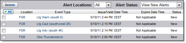
More details and options for each alert are available by clicking the link within the alert listing.
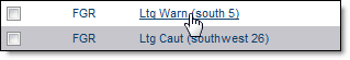
The alert detail provides additional information.
The detail is displayed along with three options:
|
|
Click Mark as Archived to archive an alert for future reference. An archived alert will remain available for up to two years. |
|
|
Click Delete to remove the alert from the list. |
|
|
After viewing an alert click Back to go back to the list of alerts. |
You can view a list of the archived alerts by selecting View Archived Alerts from the Alert Status menu. You can also choose to view only the new alerts or view all alerts.
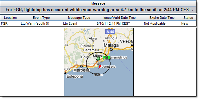
Note: When using the Lightning
and All Clear alerts you may receive up to six notices within the Alerts
screen for each event. The six notices are: advisory, caution, and warning,
warning all clear, caution all clear and advisory all clear. They will
not always occur in that fashion or order, depending on where lightning
is occurring.
![]()
Alert data will be reported in either English or Metric units as determined by your preference setting, excluding National Weather Service (NWS) based alerts. NWS advisories, watches and warnings will always use English units regardless of the preference setting.
Note: Alerts will retain the unit preferences set at the time they were generated. If an alert is generated and received while using Metric preferences, that alert will remain in Metric units even if the preferences are later changed to English units.
NEXRAD radar based alerts are available to US locations including Alaska, Hawaii and Puerto Rico. Storm attribute alerts may be available to some Canadian locations located within 124nm of a US NEXRAD radar site.
|
Alert Type |
Description |
|
Possible Tornado |
Radar detected a circulation capable of producing a tornado approaching the selected location. |
|
Severe Thunderstorm |
Radar detected storm capable of producing damaging winds approaching the selected location. |
|
Severe Hail |
Radar detected a storm capable of producing hail with a diameter of 1 inch (2.5 cm) or greater approaching the selected location. Note: The NWS has recently changed the definition of Severe Hail from .75" to 1". |
|
Any Hail |
Radar detected a storm capable of producing hail of any size approaching the selected location. |
Lightning alerting is available within your purchased region. Lightning data is an optional purchase.
|
Alert Type |
User Defined Value |
Description |
|
|
Select a warning range and advisory range between 5 and 60 miles (8/96 km). Warning range default is 8 miles (13 km) and advisory range default is 30 miles (48 km). A 3 mile (5 km) warning range is allowed in the Airport Operations Edition. |
A warning is generated if lightning is detected within the selected warning range of the location. A lightning advisory or caution notification is generated if lightning is detected within the set advisory or caution range. |
|
All Clear |
Select a time frame between 10 and 30 minutes. Default is 15 minutes. |
When no lightning is detected in your advisory range for the set amount of time, you will receive an advisory area all clear alert. Likewise when no lightning is detected in your warning or caution range for the set amount of time you will receive a warning area all clear alert. |
PrecipTimer® alerts are available to locations covered by the US composite radar which includes the continental US and Puerto Rico. Some Canadian locations near the US/CA border may fall within the US composite radar footprint.
|
Alert Type |
Value |
Description |
|
PrecipTimer® |
Any type of Precipitation, Rain only or Snow/Ice/Mix only. |
Precipitation is approaching the selected location based on the PrecipTimer® settings. |
Available to all locations.
|
Alert Type |
Description |
|
Winds > 74 mph (119 km/h) |
Winds in excess of 74 mph (119 km/h) have been detected at an observation site near the selected location. |
|
Winds > 115 mph (185 km/h) |
Winds in excess of 115 mph (185 km/h) have been detected at an observation site near the selected location. |
Available to all locations.
|
Alert Type |
User Defined Value |
Description |
|
Rain > |
Enter the probability percentage and amount |
Rain is forecast to occur within selected lead time. |
|
Snow/Ice/Mix > |
Enter the probability percentage and amount |
Snow/Ice/Mix is forecast to occur within selected lead time. |
|
Temp < |
Enter Temperature |
A temperature lower than the value you have entered has been forecast to occur within selected lead time. |
|
Temp > |
Enter Temperature |
A temperature higher than the value you have entered has been forecast to occur within selected lead time. |
|
Humidity < |
Enter a percentage of humidity |
Humidity of a lower percentage than the value you have entered has been forecast to occur within selected lead time. |
|
Humidity > |
Enter a percentage of humidity |
Humidity of a greater percentage than the value you have entered has been forecast to occur within selected lead time. |
|
Wind Speed > |
Enter wind speed |
Wind Speed or Wind Gust of greater than the value entered in Variable has been forecast to occur within selected lead time. |
|
Feels Like < |
Enter Temperature |
Feels Like Temperature, temperature lower than the value entered, has been forecast to occur within selected lead time. Feels like temperature is generated using the wind chill if below 50°F (10°C). |
|
Feels Like > |
Enter Temperature |
Feels Like Temperature, temperature higher than the value entered, has been forecast to occur within selected lead time. Feels like temperature is generated using the heat index if over 70°F (21°C). |
Available only to locations in the continental US, Alaska, Hawaii, and Puerto Rico.
|
Alert Type |
Description |
|
NWS Warnings - Community Based |
Enable all or none |
|
Tornado Warning |
Your location is included in the Area of Maximum Impact (AMI) for a tornado sited by spotters or detected by radar. |
|
Thunderstorm Warning
|
Your location is included in the AMI for a thunderstorm with spotter or radar detected winds of 58 mph (93 km/h) or greater and/or hail 1 inch (2.5 cm) or greater. Note: The NWS has recently changed the definition of Severe Hail from .75" to 1". |
|
Flood/Flash Flood Warning |
Your location is included in the AMI where flash flooding is reported, precipitation estimates indicate flash flooding is likely, or dam/levee failure is imminent or occurring. |
|
NWS Warnings - County Based |
Enable all or none. |
|
Tornado Warning |
Tornado sited by spotters or detected by radar within the county. Tornado Warnings will flash on the Layered Map. |
|
Thunderstorm Warning |
Spotters report or radar detects winds of 58 mph (93 km/h) or greater and/or hail 1 inch (2.5 cm) or greater within the county. Note: The NWS has recently changed the definition of Severe Hail from .75" to 1". |
|
Flood/Flash Flood Warning |
Flash flooding is reported, precipitation estimates indicate flash flooding is likely, or dam/levee failure is imminent or occurring within the county. |
|
NWS Watches |
Enable all or none. |
|
Tornado Watch |
Conditions are favorable for tornadoes. |
|
Thunderstorm Watch |
Conditions are favorable for severe thunderstorms. |
|
Flash Flood Watch |
Conditions are favorable for flash flooding. Dam/levee failure is possible but not imminent. |
|
NWS Advisories |
Enable all or none. |
|
Blowing Snow Advisory |
Widespread or localized blowing snow reducing visibilities to ¼-mile (400 m) or less and winds are less than 35 mph (56 km/h). |
|
Fog Advisory |
Widespread or localized fog reducing visibilities to ¼-mile (400 m) or less. |
|
Blizzard Advisory |
Blizzard conditions expected. Blizzard conditions are defined as the following for at least three hours: sustained wind or frequent gusts of 35 mph (56 km/h), falling or blowing snow, and visibility frequently ¼-mile (400 m) or less. |
|
Snow Advisory |
Snow accumulation meeting or exceeding locally defined criteria expected within next 24 hours. |
|
Freezing Rain Advisory |
Ice accumulations expected to meet or exceed locally defined criteria. |
|
Winter Weather Advisory |
More than one winter weather hazard meeting or exceeding locally defined criteria is expected. |
|
Wind Chill Advisory |
Wind chill temperatures reaching or exceeding locally defined criteria are expected. |
|
Frost/Freeze Advisory
|
Temperatures forecast to reach between 33 and 36°F (.5 and 2°C) for a Frost Advisory and 32°F (0°C) or less for Freeze Advisory. |
|
High Wind Advisory |
Sustained winds of 40 mph (64 km/h) or greater for at least one hour or sustained winds of 58 mph (93 km/h) or greater for any period. Winds are not associated with severe local storms. |
|
Heat Advisory |
Heat index values reach or exceed locally defined criteria for at least two days. |
Available to all locations.
|
Alert Types |
User Defined Value |
Description |
|
Fog |
None |
Fog reported at an observation site near the selected location. |
|
Thunderstorm |
None |
Thunderstorm reported at an observation site near the selected location. |
|
Freezing Precip |
None |
Any type of freezing precipitation is reported at an observation site near the selected location. |
|
Rain |
None |
Rain reported at an observation site near the selected location. |
|
Snow |
None |
Snow reported at an observation site near the selected location. |
|
Hail |
None |
Hail reported at an observation site near the selected location. |
|
Visibility < |
Select distance |
Visibility of less than the selected value reported at an observation site near the selected location. |
|
Ceiling < |
Enter height |
Height of the first broken cloud layer reported at an observation site near the selected location. |
|
Wind Chill < |
Enter temperature |
Wind chill less than the entered value reported at an observation site near the selected location. |
|
Humidity < |
Enter humidity in percentage |
Humidity less than the entered value reported at an observation site near the selected location. |
|
Humidity > |
Enter humidity in percentage |
Humidity greater than the entered value reported at an observation site near the selected location. |
|
Heat Index > |
Enter temperature |
Heat Index greater than the entered value reported at an observation site near the selected location. |
|
Temp < |
Enter temperature |
Temperature less than the entered value reported at an observation site near the selected location. |
|
Temp > |
Enter temperature |
Temperature greater than the entered value reported at an observation site near the selected location. |
|
Wind Speed > |
Enter wind speed |
Wind Speed greater than the entered value reported at an observation site near the selected location. |
Remote Alerting is an optional purchase. Contact your sales representative for details.
Your mobile device can receive alerts generated from the criteria which was set in the Alert Criteria page. You may use any device that can receive an email or text message including cellular phones, alphanumeric pagers, and desktop email. Contact devices can be assigned to each alert location.
Within accounts under administrator control the setup process is available only to the Account Administrator.
Click the Manage Recipients submenu option under the Alerts Menu option.
Click the New button below the Recipient list.
Enter an unique name for the device in the Recipient text field.
Select the Recipient Type; mobile phone or email.
Enter the mobile phone number
and select the provider.
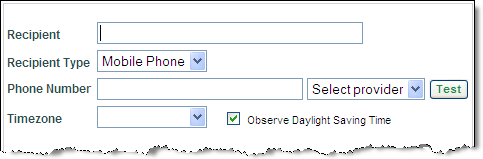
OR
Enter the email address. Email addresses may be group addresses to
reach more employees.
Always test your mobile/email
address by clicking the Test button. You can do this at any time, even
before saving this recipient listing.
You should receive a test email from accountsetup@Telvent
DTN.com.
Select the time zone for the location from the Time Zone drop down menu. If daylight-saving time is observed at the location enable Observe Daylight Savings Time.
Select either the No Quiet Period or Specify Quiet Period radio button.
If Specify Quiet Period is
selected, set the starting and ending times for up to two quiet periods.
Then select the period (daily (Sun-Sat), weekday (Mon-Fri), weekend (Sat/Sun),
night and weekend, day of the week) from the Period drop down menu. In
this example non-severe alerts will only be received between 8AM and 5PM,
Monday - Friday.
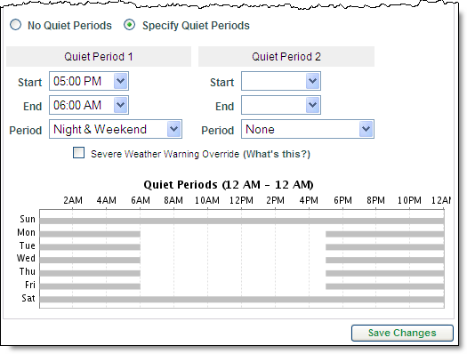
Note: You can still receive severe weather alerts for US
locations during the quiet periods by enabling Severe Weather Warning
Override. If you enable this option you will still receive notice of any
issued National Weather Service warning or Severe Hail, Mesocyclone, and
Tornado Vortex Signature alerts.
Click the Save Changes button.
If necessary, click Delete to remove a highlighted recipient.
Select up to three recipients from the Add Recipients link in the Alert Criteria screen.
![]()